Email: dgacmad@acmad.ne/dgacmad@acmad.org site web: www.acmad.net
This region typically covers the equatorial region of Africa including Cameroon, Central Africa Republic, Gabon, Congo, Democratic Republic of Congo, Equatorial Guinea, Sao Tome and Principe and Burundi. The regional climate is dominated by convective activity and precipitation in the InterTropical Convergence Zone (ITCZ) with October-November-December as the main target season.
Major sources of seasonal climate variability and predictability in the region include Sea Surface Temperatures (SSTs) of the equatorial Pacific (ENSO region), tropical northern and southern Atlantic and equatorial western Indian Oceans. Uncertainties on SST forecasts over tropical Atlantic and the equatorial Indian Ocean as well as limitations on the representation of interactions between the Congo Basin, the regional and global atmosphere are not well documented. .
Improvement of ocean models over the tropical Atlantic, land surface models over sub-Saharan Africa and coupled ocean-atmosphere-land models are required to provide better inputs to operational seasonal prediction for the region.
Improvement of understanding and representation of processes and interactions in models are required to provide better inputs to operational seasonal prediction for the region.
Floods, dry and wet spells, anomalous onset and cessation of rains are the main climate hazards of the region. Water borne diseases, roads and other infrastructure damages, loss of lives and properties are associated with heavy precipitation, strong winds and floods. Losses in food production ( up to 30%) due to heavy rains occurring during havesting period increasing humidity leading to losses or damages in crops are noted over the area..
The RCOF
The RCOF started in the early 2000s. It has been held once a year usually in late September with October-November-December as the main target season. It involves 8 countries in Central Africa namely Gabon, Congo, DRC, CAR, Cameroon, Equatorial Guinea, Sao Tome and Principe, Burundi. NMHSs of the region, WMO Global Producing Centres for Long Range Forecasts are the major collaborating partners.
The approach involves assessment of outputs from global single and multimodel ensemble forecasting systems, statistical seasonal forecasting tools, analogue years, persistence, composites and trends analysis as well as available findings from climate studies at local, national, regional and global levels. The assessment made is discussed during a briefing and a consensus outlook generated for users.
Discharge outlooks for the Congo basin and vigilance maps for heavy precipitation are additional products provided when necessary.
 |
 |
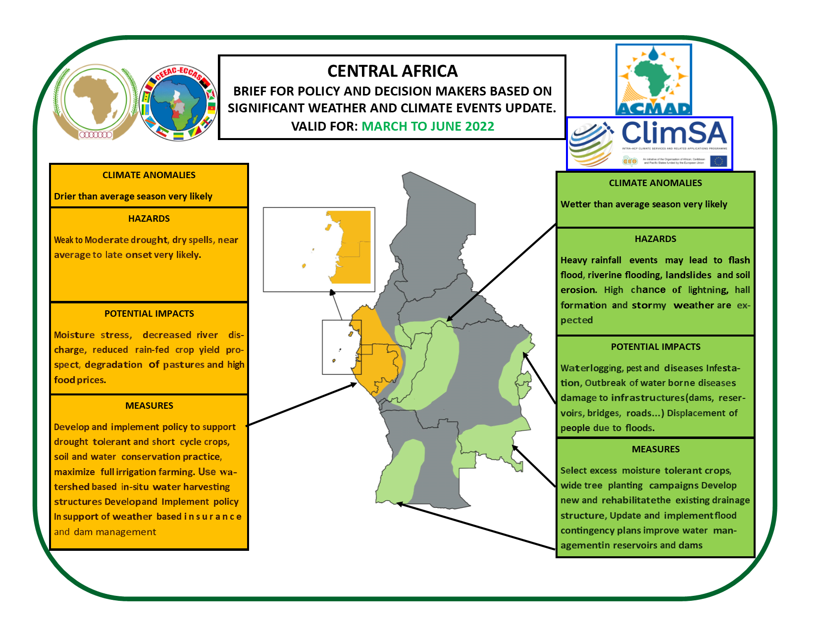 |
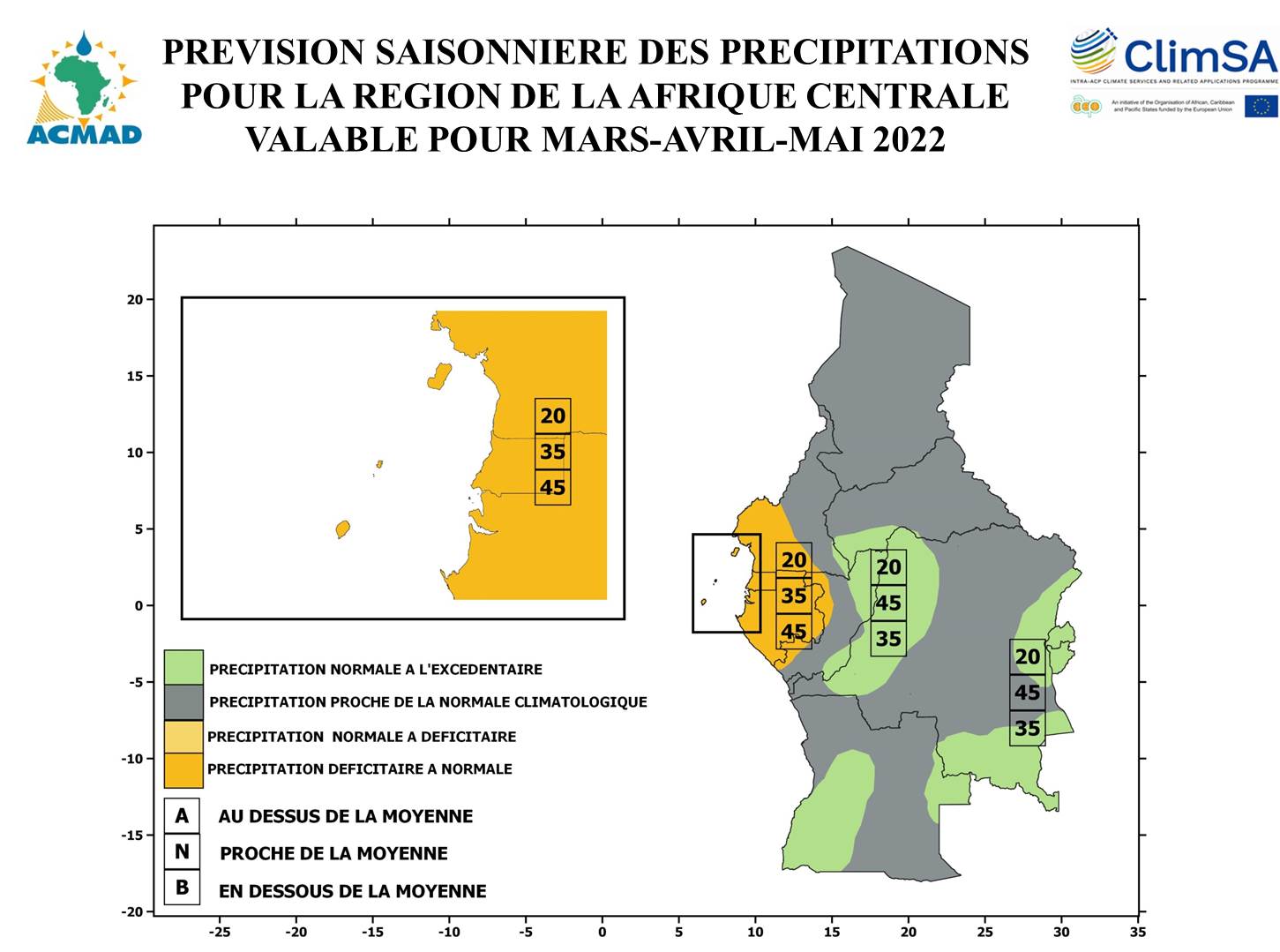
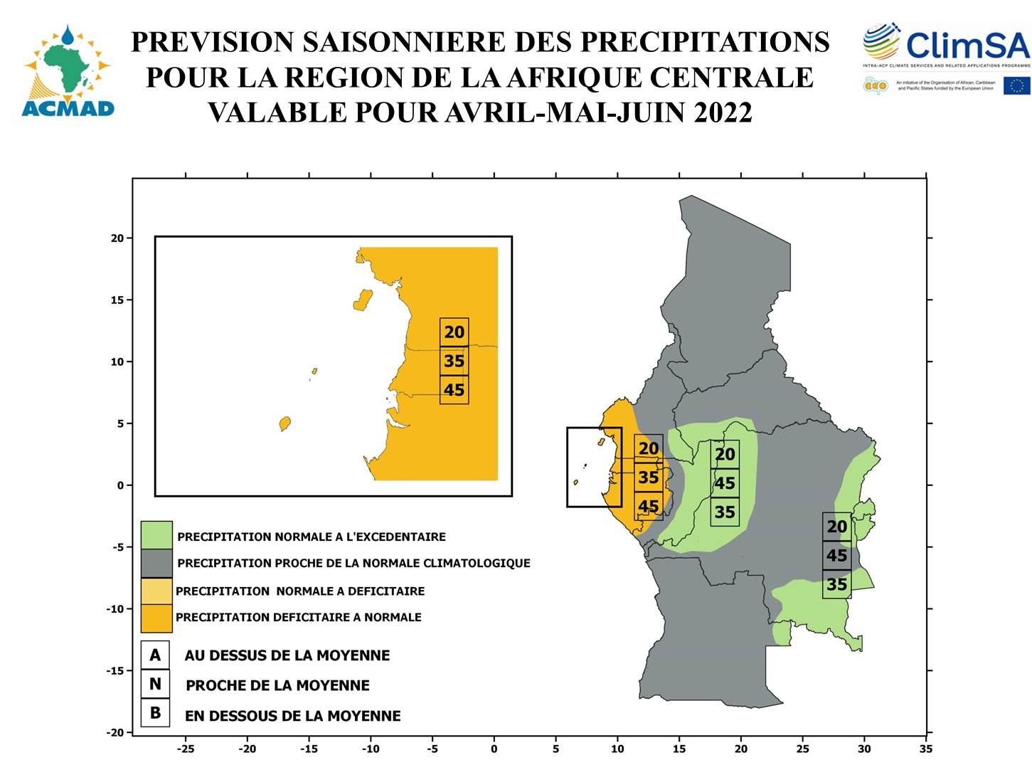
Figure : Seasonal Precipitation forecasts for Central Africa |
The African centre for Meteorological Applications for Development (ACMAD) is the main coordinating institution. Contact details: African Center of Meteorological Applications for Development , ACMAD, 55, Avenue des Ministères, PL6, BP 13184, 1er Arrondissement, Niamey Plateau, Niger, Tél: (+227) 20734992; Fax: (+227) 20723627. Email: climat@acmad.org, website: www.acmad.org/rcc .
User involvement
Users from agriculture, water, disaster management and media communities are invited to the forum for exchanges, interactive discussions on the historical, current and expected climate conditions, related impacts, advices and recommendations to cope with negative impacts or increase benefits linked to possible opportunities due to favorable climate conditions..
Success stories based on feedback of users
In 2008, ACMAD issued an update of consensus prediction for the region with high probability ( up to 50%) for above average rainfall over much of the southern Sahel. Wet to very wet years in the region are usually associated with higher frequency of heavy rains and floods. The forecast was used for an appeal by Red Cross for funding for flood preparedness. The funds were granted leading to prepositioning of relief items (mosquito nets, blankets…). Without this forecast, items would have been provided after floods. The efforts would have then cost more in time and transport expenses. This was the first time in Red Cross’s history that based on seasonal forecasts, funds were requested and used to prepare for potential emergency. Wet years are also related to more mosquitoes and malaria in Sub Saharan Africa. UNICEF office in Niger used seasonal forecasts to prepare and preposition drugs and mosquito nets for vulnerable communities.
Way forward
Scientific research on ocean-land-atmosphere modeling, new predictors for statistical forecasting tools, local and regional climate variability and trends studies, assessment of regional performance of forecasting systems including their strengths and weaknesses in predicting regional climate features are proposed to improve consensus outlook products. Specifically better understanding and prediction of the Gulf of Guinea SSTs and interactions between land and the atmosphere over the Congo Basin are required.
Participation of climate service providers in user forums namely regional and national contingency planning meetings, agriculture season planning workshops, vulnerability assessment and water forums is important for effective exchanges, interactions, consensus building and tailoring of products including measures, advices and recommendations. Provision of climate outlook in August instead of September each year, regular provision of discharge outlooks and vigilance maps are needed for further engagement of a wider range of users and expansion of forecasts application opportunities.
Clik here to see outlook bulletin PRESAC
Clik here to see the press release